“Sydney Metro Northwest and Sydney Metro City and Southwest combined will deliver 31 metro railway stations and more than 65 kilometres of world–class metro rail.” So claims Andrew Constance, NSW Minister for Transport, in his opening to the Sydney Metro Environmental Impact Statement Summary for the Chatswood to Sydenham portion of the project.
It sounds good. It sounds city-changing. And while a pedant (definitely not me) could rightly argue it is, in fact, true, it is also without doubt misleading. To understand what we’re actually getting, let’s have a closer look at the Sydney Metro and its four distinct parts:
- The new Northwest Metro from Tallawong (formerly Cudgegong Rd) to Epping, due to open in 2019
- The existing Epping to Chatswood Rail Link that opened in 2009 and was closed this year for metro conversion
- The new 16.5km metro tunnel from Chatswood to Sydenham via the CBD, and
- The existing Bankstown Line from Sydenham to Bankstown that will be closed in the near future to be converted to metro service
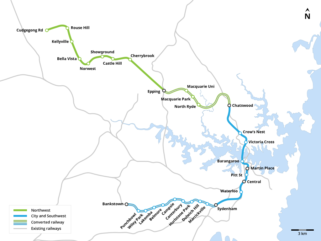
The four distinct component parts of the 65km Sydney Metro line.
Source: Wikimedia Commons.
The 31 station claim sits somewhere between hyperbolic and an outright lie when you consider that 18 of these ‘new’ stations are existing Sydney Trains stations that are being upgraded for metro service. In fact, aside from the Northwest Metro, the project barely provides any new coverage to areas not already served by Sydney Trains.
It’s not that I dispute the merit of the project. Network constraints in the CBD mean that in peak hours Sydney Trains are running more or less at capacity. A second harbour rail crossing was flagged as necessary as early as 2001.
The way the metro is being executed, however, has raised more than a few eyebrows. There’s been complaints about lengthy station closures (which the state government was hoping to soothe with a Lee Lin Chin branded ad campaign) and the ‘developers vs the rest of us’ David and Goliath battle over routing the line via Sydney University or Waterloo. A battle that inevitably ended with a station being placed immediately under a large tract of State Government owned land.
In fact, while the then Premier made sure that Waterloo got a brand new station, not many other places did. The Chatswood to Sydenham ‘CBD’ portion of the metro runs under one of the most densely populated parts of the country, yet it will only include 9 stations. That’s an average of over 2 km between each one.
To better understand what this means in practice, I want to unpack an important (but not particularly glamorous) transport planning concept: walking catchment.
Walking Catchment – how far would you go?
Walking catchment refers to the distance that transport planners assume an average person is willing to travel to access public transport. Thanks to the (often hidden) importance of the imperial system in our society, these distances are given at 400m for a bus service and 800m for a train station. These catchment areas attempt to simplify extremely complex human behaviour into an easy to apply metric. For those interested, Daniels and Mulley do a great job of considering how well they work in practice in Sydney. The concept still holds considerable currency in transport planning and so for my purposes I will stick with the walking catchment area of a station being 800m radius.
Thus, for a line providing continuous local service along its length, stations should be spaced roughly 1.5km apart. We see this across much of Sydney. The North Shore Line, Inner West Line, Illawarra Line and the portion of the Bankstown Line that will be converted into metro all have stations spaced roughly this far apart. On a suburban or express line, where users take a feeder bus or drive to a station, greater spacing is typical as this allows trains to reach faster speeds.
For the Sydney Metro from Chatswood to Sydenham this means that with average spacing of over 2km, even if you live directly above the new metro tunnel, there’s a good chance you will live too far from a station for it to be of much use to you. From this it seems that the motivation for the metro is to provide a fast service connecting the CBD to the suburbs rather than to provide a traditional urban metro service with closely spaced stations in walkable neighbourhoods.
Let’s take a closer look at the project. Of the 9 ‘new’ metro stations between Chatswood and Sydenham there are:
Our brand new 16.5km metro includes no stations that are not already within the walking catchment of an existing train station. With so much of the city under-served by reliable public transport, spending over $12 billion on an urban rail project that will increase coverage so insignificantly seems questionable.
The forgotten 32nd metro station
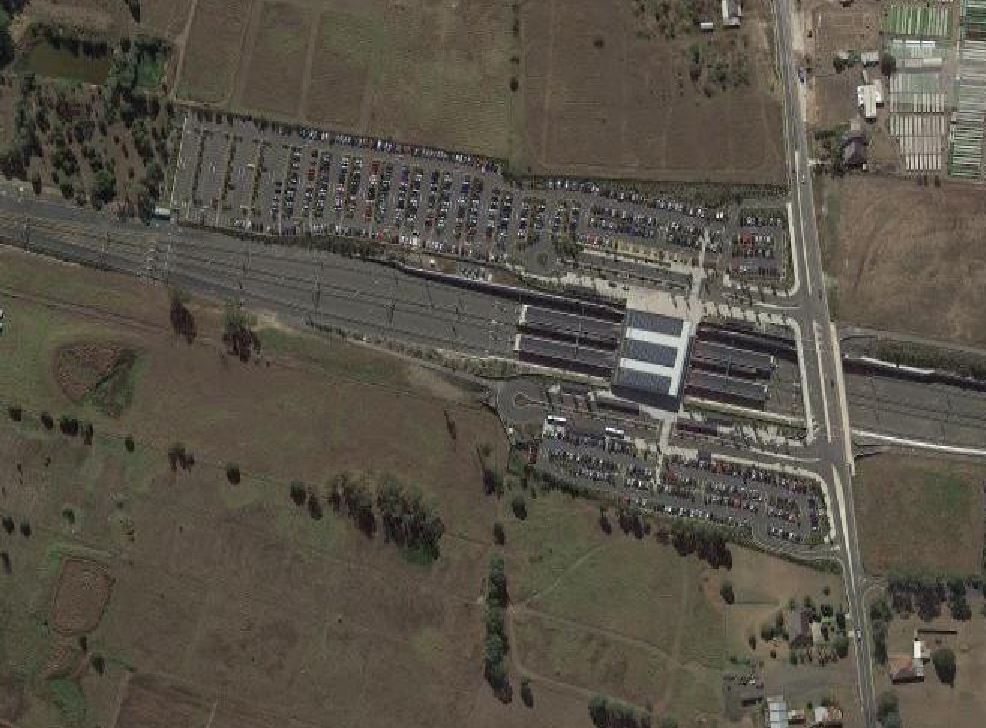
There is hope, however. The line includes a 4 kilometre long station-less stretch between Waterloo and Sydenham. This stretch of track runs under one of the most economically significant, high density, traffic choked and poorly served by public transport parts of the city. It represents the perfect opportunity to adjust the Sydney Metro plan to include a new station. Alexandria Station would provide much needed rail coverage to an area that is a centre of employment and housing, and is already suffering from extreme traffic congestion that is slated to only get worse upon the completion of Westconnex.
A station near the corner of Euston Road and Maddox Street in Alexandria would be 1.3km from Waterloo and 900m from the closest Sydney Trains station at Erskineville. If built, it would be the only new metro station between Bankstown and Epping that is not within walking distance of an existing train station. It’s also right on the tunnel corridor, so no realignment would be required.
In fact the case to build a station at Alexandria is so compelling I decided to dig further and try and figure out why it wasn’t included in the current plan.
This map shows the potential station sites that were investigated between Central and Sydenham for the 2015 Infrastructure Report. Despite the plethora of investigated locations, the Alexandria station site wasn’t considered at the time.
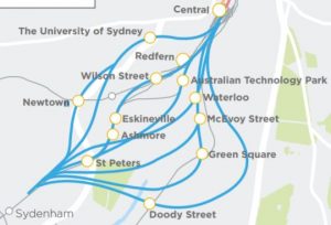
Station locations between Sydenham and Central that were investigated as part of the Sydney Metro planning process. The final choice was for one intermediate station at Waterloo. Source: Sydney Metro.
In May 2016 the EIS was released stating that the chosen alignment would run from Central to a new station near the corner of Botany Road and Raglan Street in Waterloo, and then on to Sydenham. The response to the lack of a station in Alexandria was clear. Unlike many of Sydney’s current infrastructure projects, such as Westconnex, the residents of the area affected by a new Alexandria Station are strongly in favour of it. Members of the Alexandria Residents Action Group have been lobbying government for the past two years to include such a station. But it’s not just residents, elected officials have had this to say:
From the City of Sydney’s submission to the Chatswood to Sydenham EIS:
“The City also recommends that an additional station is included in the alignment between Waterloo and Sydenham to service the growing Erskineville and St Peters area. The stop should be developed under Mitchell Road or McEvoy Street.”
From the Inner West Council’s submission to the Chatswood to Sydenham EIS:
“Council encourages the addition of an extra new station be included as part of the project, located between Waterloo and Sydenham Stations. The Alexandria/Ashmore areas continue to experience significant employment and residential growth; an additional Sydney Metro Station in this vicinity would allow access to increased employment opportunities in the Southern Sydney employment area and provide much needed public transport connectivity for residential growth already occurring in this precinct.”
From the Member for Heffron Ron Hoenig’s speech to parliament:
“I have previously made representations requesting that the Government consider a metro rail station at Alexandria, but they were rejected out of hand. Alexandria is a rapidly growing suburb. It is at the fringe of the mammoth Green Square project and the Ashmore Estate project. Alexandria is smack bang in the middle of the “global economic corridor” from Sydney’s central business district through to Sydney Airport and Port Botany. It is also in the heart of the City of Sydney’s southern employment lands, a significant segment of industrial land still remaining in close proximity to the CBD. Put simply, Alexandria is one of the most important suburbs in the most economically significant precinct in the country, and this Government will not connect it to its city-shaping metro project.”
Transport for NSW’s full response to these submissions and many others regarding an additional station between Waterloo and Sydenham can be found here, on pages 330-333. In regards to station site selection, they had this to say:
“where there is an existing rail station, or the potential station location is within close proximity to an existing station there would be limited increase in rail catchment, limited change to public transport from private vehicles and no significant relief to existing public transport services.”
With this response they refute the need for a new station at Alexandria due to its proximity to existing stations. Bizarrely, it could be even more obviously applied to Crows Nest, Waterloo, Barangaroo or any other station on the route, which are all much closer to existing stations than Alexandria would be. I can only assume the irony of this is lost on the authors of the paper.
The response goes on to outline, in reasonable detail, why a station in the area isn’t in line with the project’s goals. It reads as a justification for a decision already made rather than an investigation into a legitimate concern. What I can’t understand is why the State Government has taken such a firm stance against a station in Alexandria.
Alexandria: a city on the grow
In an effort to summarise the arguments as to why a new station on the existing metro alignment is a no-brainer, I’ve come up with four transport challenges facing the area that would be addressed by building Alexandria Station.
It is in the heart of an earmarked growth area for employment and immediately adjacent to multiple high density housing projects.
Alexandria is no longer a light industrial backwater, it is fast becoming a centre for medium and high density residential and commercial uses. Its light industrial history and unique zoning so close to the CBD makes visiting Alexandria a frequent occurrence for residents and businesses in the inner suburbs seeking to access “essential industrial services”, according to the City of Sydney Employment Lands Planning Proposal.
The City of Sydney Southern Employment Lands is a study area covering the predominantly light industrial parts of Southern Sydney, stretching from McEvoy Road and Wyndham Street in the north to Gardeners Road in the south. In 2015 new planning codes were adopted for the area that will lead to an increase in more valuable and denser land uses.
In the area in which a new Alexandria metro station would be located, the City of Sydney forecasts job density almost doubling from 76 jobs/ha in 2015 to 120 jobs/ha in 2031. Roughly speaking, 5,000 people could be employed within walking distance of the new station by 2031. This is without any of the sort of land uses changes that have been used to justify a station at Waterloo.
In terms of residential population, the station would be immediately adjacent to the existing historical Alexandria neighbourhood that consists of terraces, townhouses and small blocks of flats. It would be within walking distance of existing high density apartment complexes at Sydney Park Village. It would also be the closest train station for much of the under construction Ashmore Precinct that, when complete, will be home to some 6,000 people. Also within walking distance is the ‘East McEvoy Investigation Area’ that is slated for high density mixed use development in the future.
This map shows 2016 residential population density in the area, the three marked development sites (in pink) are under-construction or planned development sites. These areas will probably end up shaded dark blue, for high density, in future renditions of this map. The areas with no population are mostly light industrial and commercial uses.
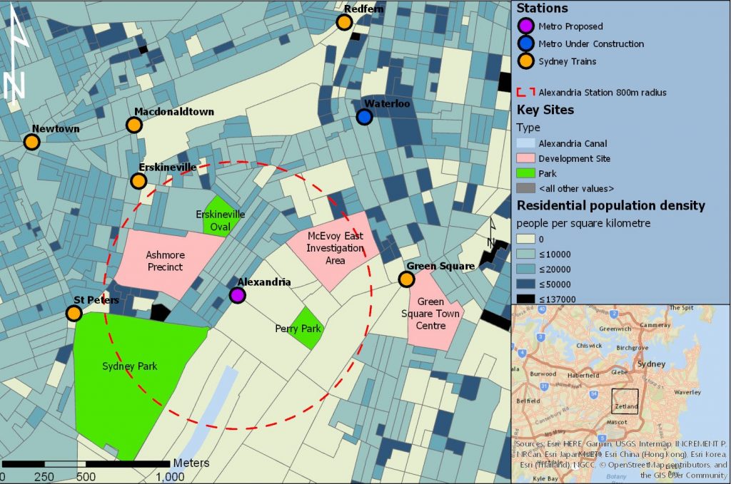
Population density and residential growth areas accessible to a new Alexandria Metro Station. Sources: ABS, Esri.
Traffic congestion is terrible and is only going to get much, much worse.
Given the state of Sydney’s roads, it would be a bold claim to say that Alexandria experiences the worst traffic in Sydney, but there’s no doubt traffic in the area is extremely problematic. There’s much concern as to how gridlocked roads will deal with the completion of the Westconnex New M5 that will see a six lane freeway funnel directly onto McEvoy Street.
This congestion makes bus services through the area inherently unreliable, as regular users of the 370 will attest. It also means that a bus-based solution to traffic in the area is never going to be successful. Currently 75% of commuters to the Southern Employment Lands commute by car, and the City of Sydney have made it clear that that the area can only sustain an increase in density if mode share use changes drastically in favour of public and active transport.
The three nearest rail stations are already over capacity and construction of new housing continues apace.
The justification for the new metro is to free up capacity for heavy rail services running into the CBD. The three stations nearest to Alexandria (Green Square, Erskineville and St Peters) are all over capacity in the AM peak. This is only going to get worse with the completion of large apartment complexes in the vicinity of all three stations. The additional services on the Airport and East Hills Line that may become available upon completion of the metro will hopefully lead to decongestion of Green Square, however what will happen once St Peters and Erskineville become stations on the already crowded Illawarra Line?
A new station at the periphery of all three catchment areas will provide a direct service to employment centres in Barangaroo, North Sydney and North Ryde and relieve strain on the existing stations.
Much of Alexandria’s workforce commute from the Bankstown region and would benefit from the direct link.
The City of Sydney’s Employment Lands Transport and Access Report shows that 9% of the commuters to the Southern Employment Lands come from the Canterbury-Bankstown region. Without a station at Alexandria, reliable public transport connecting the Bankstown Line to this area will not exist, leaving a trip by private vehicle (or an arduous multimodal commute for those without) as the only option.
From where I stand it’s sad to see the metro going ahead in its current form when a minor change could make it so much better. I do hope at some point in the near future the plan is reconsidered and adjusted to include a new station at Alexandria. Until then I suppose I’ll just have to stick to the 370.