Travelling by Transit across the Rustbelt – Part 2: Detroit to Buffalo

Suggested reading: Part One: Motor City.

The next scheduled stop on my trip was Syracuse in upstate New York. I wasn’t meeting my friend there for a few days so I had some time to make my way across leisurely.

Planning my trip East from Detroit I had the lyrics of Detroit or Buffalo looping around in my head:

Better pack up and go
Detroit or Buffalo
Anybody wanna know where, I don’t know
I don’t know
God knows everybody gotta go sometime
And I’m takin’ this train to the end of the line
Missin’ every mile that friend of mine

I wanted to take that train, if not to the end of the line than at least as far as Buffalo. I just didn’t feel like I’d be doing Barbara Keith justice boarding a Greyhound. That, I live in a (passenger) train-free area, and I don’t particularly enjoying short haul flying. So I wanted to use this trip as a chance to catch as many intercity trains as possible.

Unfortunately, heading East from Michigan is a huge blackhole in Amtrak’s often patchy coverage. It’s not as bad as Wyoming or South Dakota, but it’s pretty bad.
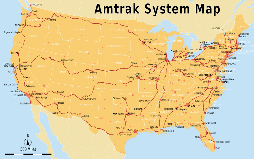
The Amtrak System Map. At this scale Southern Michigan looks like a train traveller’s delight! Source: wikimedia
Red are trains, green are buses. At this scale it’s clearer that all the trains in Michigan head West to Chicago. To head East on the Lakeshore you need to get to South Bend, Indiana or Toledo, Ohio. Source: Amtrak

I guess Ohio never forked out for some State-subsidised local Amtrak service like the Cascades in Washington and Oregon or the Wolverine in Michigan. This means that only long distance trains pass through Ohio and they are set up for travel across the State more than within in.

The busiest of these is the Lakeshore Limited. She is a flagship long distance passenger train, connecting what might just be America’s two most traditionally transit friendly cities, Chicago and New York (also Boston, the train splits at Albany with half heading South to NYC and the other half continuing East). Sadly, like most long distance Amtrak trains the Lakeshore only runs once a day. It also leaves Chicago at 9:30pm which I believe is designed to provide a direct connection with the Empire Builder and California Zephyr coming from the West. They arrive in Chicago midafternoon, so I guess Amtrak wants some leeway so it’s not refunding tickets and providing complimentary hotel beds left, right and centre.

This all means that the Lakeshore hits Toledo, Ohio at the travel-friendly time of 3:15am. It’s hard to justify taking a five and a half hour train trip when you know you’ll sleep or be totally zonked out the whole way and arrive at your destination not yet able to check-in but too tired to enjoy the sights and sounds.

That’s annoying, but still manageable. What makes this train basically uncatchable is that the Amtrak Thruway coach that connects from Detroit to Toledo inexplicably leaves Detroit at 9:30pm, arriving in Toledo at 10:35, a casual four and a half hours before the Lakeshore Limited is due. I have no idea why this is the case, and since the Amtrak station in Toledo is in a quiet, mostly industrial neighbourhood at the edge of downtown, that would be a long wait. Oh, and the Lakeshore runs late around half the time, earning it the clever nickname the “Lateshore Limited’.

So, I gritted my teeth, hit pause on Detroit or Buffalo and pressed play on Simon and Garfunkel’s America.

If I wasn’t so tight (and stubborn), for around 250 USDs there are multiple daily direct flights between the two cities. But I am (on both counts) and so I paid $70 for the pleasure of taking a series of crowded coaches to make the trip.

At 4:30pm, half an hour late, I boarded the bus from Detroit’s unloved Greyhound station bound for Cleveland. There I had an hour to attempt to find something to eat in the area that didn’t come from a vending machine, before jumping on a full Baron’s bus bound for Buffalo that pulled in at 11:30pm.

It was a long evening.

In Buffalo

Having spent plenty of time in Detroit but barely visited anywhere else in the Rustbelt I was labouring under the false impression that the faded glory of turn of the century America was best experienced in Detroit. How wrong I was. Buffalo’s downtown architecture was at least as epic, and they had the inspired idea to stick a light rail through the Downtown spine a good 40 years before the Q-Line was conceived.
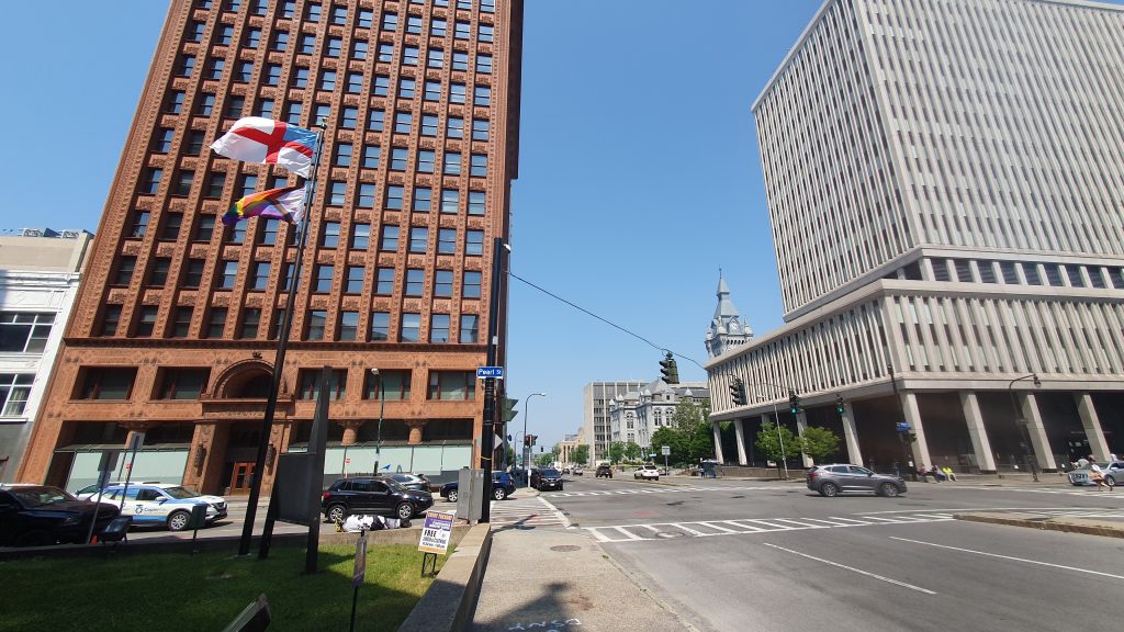
Wide streets, tall buildings, homelessness: ‘merica!

Downtown Buffalo rejuvenation

I was only in Buffalo for a hot minute and was mainly there as a stopping off point for Niagara Falls. In the wanderings I did manage on my brief visit I was struck by two things:

1. Vibrant queer scene!

Buffalo has a bustling theatre scene and what appeared to be a very prominent queer scene as well. I think the fact that I rolled into town on the last night of Pride was probably a factor here but the bricks and mortar presence of gay spaces make it apparent this wasn’t just a one-off thing.

I mean come on people Buffalo’s nickname is the Queen City.

Good vibes.
This one might be Pride specific. This is Main Street in the Theatre District. To the right of the frame is the portal where the Buffalo Metro stops activating Downtown’s retail core and heads underground for a quicker connection to the suburbs.

2. Attempts to ‘bring back Downtown’

So prior to this trip my thinking about urban blight and declining downtowns in the Rustbelt and beyond went something like this:

  • Early 20th century: Streetcar suburbs, manufacturing boom, prosperous bustling downtown.
  • Mid century: Rise of the automobile, racial desegregation, growth of suburbia, freeway sprawl, loss of manufacturing jobs, decline of Downtown, abandoned buildings cleared for parking lots.
  • Late 20th century: People realised suburbia is boring and diversity is good. Gentrification. Rise of Downtown as a cultural hub and desirable residential area with less of an emphasis as a commercial hub and very limited manufacturing (mainly just breweries).

In Buffalo I found out I was kinda right but I was missing a bit in the middle. What happened there (and I’m going to extrapolate and assume this was a general trend) was that when the decline began in the 1960s the city government put their heads together to figure out what they could do about it. This bit had always eluded me. I’d thought that once the Downtown starting to decline everyone just sort of shrugged and starting spending their time and money at suburban office parks and the new enclosed malls that sprung up on the edge of cities in the 1970s.

Being in Downtown Buffalo I realised that this was crazy. The architecture alone is staggering. City Hall looks like this:

The epic Buffalo City Hall completed in 1931 (eeep bad timing), the snazzy 2011 Federal Courthouse and an obelisk commemorating the assassination of President McKinley which took place in Buffalo in 1901. The City Hall is just as epic inside, but sadly the (free!) observation deck was closed on the day I went.

The amount of wealth and prestige Downtown must have been incredible. And of course, all those fancy bankers, industrials and city officials want a nice, bustling area next door to their office and steady demand for their various premises.

So Buffalo came up with an ambitious plan to fix Downtown. The idea was that since suburbia had sucked a lot of demand away, the existing area was too large and not what people wanted. Best to turn Downtown into the equivalent of a giant outdoor shopping mall. To do this all the activity would be funneled onto a single main street which would be partially enclosed and flanked by parking garages accessible directly from the freeway network. A new light rail would run up that main spine.

The bit I had never really considered is that all this ‘urban renewal’ was phenomenally expensive. It required a lot of expertise and money in an increasingly broke urban environment. The city had one shot to reinvent itself in the post-automobile world and the landscape we got is the legacy of that era in cities across the world, but most notably in the Rustbelt.

The Regional Centre: A Comprehensive Plan for Downtown Buffalo” (1971) brought in all those ideas we know and hate: expansive ring freeways, abundant peripheral multistorey parking garages, a covered pedestrian mall, lots of full-block towers. A lot of this got built but what the planners didn’t count on is that if you cut off Downtown from the rest of the city like this there isn’t much incentive to build there or go there and so people don’t. THIS is why so many US cities have vacant lot car parks taking up entire city blocks. For years and years the demand for anything else to be built just hasn’t been there.

Downtown Buffalo today

Today Buffalo is a mix of incredible art-deco and late 19th century architecture, a rather loud and imposing light rail that doesn’t run frequently enough and a very, very visible homeless population.

Whoever decided high floor streetcars with pop-out staircases on some carriages and at-grade boarding at a single door accessed through this edifice are a good idea needs to have a long hard think about what they’ve done.

Even the single street that the aforementioned 1970s renewal plan funneled all the retail into, Main Street, is too long for the amount of commercial demand. So while there are vibrant stretches of the street, particularly up in the Theatre district, there’s an awful lot of dead space around too and that’s just on the main street (Main Street). In more recent years cars have been reintroduced to some sections of the street in an attempt to bring back some life, even if it’s just people moving to and from their parked vehicles.

Like Detroit, I got the impression that Buffalonians love their city (more than the regular amount) and have continued their city’s legacy of punching about its weight culturally.

Sorry ’bout it.

There’s no doubt Buffalo has a lot of problems, but all in all it’s the sort of city I’m kinda sad we don’t have in Australia. A place with a rich and vibrant arts and culture scene that isn’t an ‘alpha’ city with x millions of residents and sky-high rents. A place you can afford to live in a walkable neighbourhood that has interesting things going on.

Is that too much to ask?

Next up: Part 3: Niagara Falls, USA

One last thing before you go:

I’ve more or less abandoned my facebook and twitter accounts so come find me on mastodon if you fancy that early 2010s twitter vibe. Alternatively, sign up to get emailed when I post.

Travelling by Transit across the Rustbelt – Part 1: Motor City

From one autocentric city to another

The closest commercial airport to my home is YYC – Calgary International Airport. Like everything else in Alberta (often called the Texas of Canada, which can be a complement or an insult, depending on context, usually the latter) it is a sprawling piece of infrastructure. Airport hotels are literal miles away from the terminal across a sea of freeways, empty fields and the ubiquitous parking lots.

Given the Albertan love of (read: unfortunate need for) the automobile it makes sense that in May this year Westjet (known in Calgary simply as ‘the airline’) launched a direct flight to Detroit, the world’s infamous Motor City.

Of course, being me, I had no intention of making use of either airport’s abundant long-term parking, car rental offices or even taxi ranks. Instead, I arrived at YYC on the 300, a rapid (limited stops) bus route that runs from Downtown, up Centre Street and then to the Airport every 30 minutes. It’s a decent service and only costs the standard Calgary bus fare of $3.75, although as is common in North America the driver doesn’t offer change and I was ill-prepared, so I stuffed a $5 note into the fare box and climbed aboard.

A photo of a bus stop.
The 300 leaves from Centre Street in Calgary’s very ’90s Chinatown. The whole area (and transit to the airport) will be getting a massive refresh when the C-train Green Line opens in 2027.

Calgary Airport has a transit surcharge!?

A weird aside about the 300 fare: there are two bus routes to Calgary airport, each running at 30 minute daytime frequency; the 100 to the local C-train station and the 300 to Downtown. If you board either bus bound for the airport you pay the standard flat fare for riding Calgary Transit – $3.75 including a 90 minute transfer.

BUT, if you are leaving from Calgary airport on the 300 to Downtown, the ticket vending machines at the airport seem to imply you are supposed to buy a special $12 airport ‘boarding pass’ ticket. Sadly I didn’t photograph the vending machine and there doesn’t appear to be any particularly current information about this online so I’m not 100% on what the deal is. But, I did find a PDF on the YYC website from 2011 that, aside from a few fare hikes, seems to reflect the current situation.

12 years out of date but aside from a $4 increase in fare I don’t think anything has changed. Sourced here.

I ended up boarding a 100 to the McKnight C-train because it came first (and to avoid potentially getting stung an extra 8 bucks by the driver) so I can’t confirm exactly how this works. Given that the 300 is pretty infrequent and the airport stop is outside, under an overpass with minimal signage, no next service display or basic amenities it is pretty rough to sting customers with a surcharge anyway.

But I guess that’s just, like, my opinion, man.

Touchdown Motor City

Landing at DTW (Detroit Metropolitan Wayne County Airport) I wasn’t expecting too much. On previous visits to Detroit I’ve arrived at the Amshack and at the Rosa Parks Transit Centre (thank you Megabus) and both these places, while meeting the basic requirements you’d expect of arrival facilities, leave no doubt in your mind that the city (country?) has seen better days.

A photo of the Detroit Amtrack station
The Detroit Amshack. I’ll keep mentioning this because it is an absolute disgrace. Credit: Detroit Free Press

Arriving at DTW is a different kettle of fish. Detroit might have so famously declined through the latter half of the 20th century, but the greater Detroit metro region has always been just fine, thankyou very much. The airport is the 20th largest in the country, moving some 28 million people last year.

Befitting the Motor City it will come as no surprise that, like Calgary, there is no rail based transit from the airport. There’s a cute little train running between the terminals, because weirdly cute little trains within airports (or theme parks or between casinos) don’t seem to offend Americans like the real kind.

Good news though, since 2018 the airport isn’t completely cut off from any kind of public transport. The 261 Michigan Ave FAST bus is a rapid route that runs from the airport all the way Downtown. I was keen to give it a try.

Finding the bus stop proved more difficult than I had anticipated

Now leaving this major airport there are signs that direct you towards ‘Ground Transportation’ with a little pictogram of a taxi and a bus. Knowing that there is no rail transit to the airport I figured this would direct me where I needed to go.

Instead, it took me into a multi-storey parking garage that also included a layover area for coaches and shuttles heading to hotels and more, further afield parking lots. Any sort of local transit type bus stop was conspicuously absent, so I headed back into the terminal and found a sign that directed me to the City Bus stop. That was good but then the next overheard sign didn’t mention it at all, so I asked a helpful information guy who directed me to the furthest section of the car drop off area. Here, the stop was marked by a simple bus stop sign like you’d expect to find on a forgotten suburban corner; no timetable, no frequency information, no nothing.

A photo of what appears to be a car pick up/drop off area outside an airport terminal but is actually a bus stop.
This is the bus stop at Detroit airport. Note the temporary signs on concrete blocks (hey, it’s only been open for 5 years, give them a break) and the multiple cars using the bus stop as a drop off area. When my bus did come and I had to pick my way between them!

And, as you’d expect from such an unmarkable strip of roadway, the people going about their business dropping off their loved ones/uber fares at the airport paid no heed to where the bus stop ended and their designated drop off area began.

This meant that when my bus did show after just 5 minutes of waiting (a lucky break, they run at 30 minute headways) the driver just kinda pulled up in the middle lane and glanced over to where I was sitting. I jumped up and squeezed past the parked cars and idling shuttle buses to climb aboard. As soon as I had paid my $2 the doors swung shut and off we drove; the driver and me. As we sped onto the flyover that led out of the airport I couldn’t quite believe that of all those people pouring out of the place in 30 entire minutes I was the only person that was taking the practically free bus Downtown.

I assume everyone else had got taxis or hired cars, but surely some of them would have appreciated knowing this perfectly decent service existed. Perhaps some functional signage or, you know, a timetable would help here.

Riding the 261 Michigan Avenue FAST

The 261 stopped about every mile or two down Michigan Avenue at major crossroads and shopping districts, although the first half of that journey is pretty much the Detroit of popular imagination. This area isn’t actually in the city proper, but it consisted of mostly vacant lots, cheap motels and run-down gas stations.

A photo of the inside of a bus
Until we got to Michigan Ave the 261 was my own private ride. Props to SMART on the info display. Clear, accurate info and estimated travel times along the route. It’s amazing how few cities outside of East Asia and Europe can pull this off. At $2 I declare this bus to be a certified DEAL.

Once the bus got to Dearborn things out the window started to improve. There’s a tarted up new bus interchange at the Dearborn Amtrak station which is definitely better than the much larger Detroit’s train station. The bus passed through a bustling Arabic neighbourhood and some more gentrified and prosperous looking suburbs before driving by the grand old Michigan Station (more on that later) and reaching the Rosa Parks Transit Centre downtown without event.

Well, excepting the guy who stood up from the back seat of the bus and announced to us all that he was having a hard time and could someone please spare a cigarette.

The infamous Detroit Downtown

I’ve visited Detroit three times; in 2013, 2015 and 2023.

This time I was blown away by the changes happening downtown. A hipster-ish coffee shop I had visited in 2013 had seemed at the time to be in a bizarre location, surrounded by abandoned buildings and bleak multi-storey parking garages, is now next to a pedestrianised arcade and surrounded by other coffee shops, grocers and small bars.

The city’s main North/South thoroughfare, Woodward Street, now has its own streetcar (more on that shortly) and as it runs past the Fox and Filimore theatres with their neon lights and art deco stylings you’d be forgiven for momentarily thinking you were in New York, San Francisco or Chicago.

A photo of downtown Detroit at night.
Detroit: a city on the grow! (Please ignore People Mover in foreground)

The architecture in Detroit is as good as, or better than, anything those three cities have to offer and as the gaps between the buildings slowly fill in with surprisingly well considered and thoughtfully designed new buildings, a new iteration of one of America’s great downtowns is being born.

The Q-Line

The Woodward Streetcar, inexplicably known as the Q-Line, is typical of some of the many problems that plague transit in U.S American cities.

At some point in the early 2000s it became widely acknowledged that the whole all-in on the car thing wasn’t really working out. Young and upwardly mobile people actually wanted to live in a city with transit, safe cycling and some basic pedestrian amenity. In most of the world this would be considered reasonable, but it was a shock to the governments of American cities that has spent the preceding 50 years removing any last remaining vestiges of these things and replacing them with (you guessed it!) more car lanes.

So, around the same time in the 2010s a whole bunch of cities decided to build new light rail downtown. The general idea being to link the gentrifying hipster neighbourhoods on the city fringe to the downtown core. The idea is decent (trams = European vibes) but the execution came up against two very frustrating road blocks that make these systems generally pretty shitty.

A photo of the Q Line in Downtown Detroit
Apparently I didn’t take any photos of the Q-Line so here’s one from wikipedia. Credit: Bluediamond616

The Detroit Q-Line handily exhibits both characteristics!

Problem 1: No right of way

Thanks to the aforementioned planning decisions of the past 6 decades Detroit has an abundance of road lanes downtown. It is the Motor City after all.

Woodward, the thoroughfare on which the Q-Line runs, is 6 or more lanes wide for most of its length. It is mainly used for local traffic as it has not one, but two, 6-lane freeways paralleling its route within a mile of the road. ‘Merica.

An aerial photo of the Woodward corridor Q Line route
Yellow are 6 lane freeways, Red is the length of the Q-Line on Woodward. There is literally no reason for through traffic to use Woodward. Source: Google Earth.

The whole point of the Q-Line was to rejuvenate the Woodward corridor and they have honestly done a great job of that side of things. But how, given all these available lanes, the city couldn’t bring themselves to spare just TWO for the streetcar is beyond me.

In the 1940s streetcars ran down Woodward on convenient median tracks. 80 years later and this kind of smart design rarely occurs in American cities. Source: US Library of Congress

Yes, the Q-Line runs in mixed traffic which is a disaster for its reliability and a frustration for its many users. On Game Day (there are three enormous stadiums right next to Q-Line stops but the Game Day I witnessed was in fact the Detroit Grand Prix) the traffic jams would completely break the system, so staff are out there early dropping traffic cones to create temporary tram-only-lanes on Woodward and shouting at idling vehicles to keep the claimed lanes free of traffic.

This approach is so unbelievably American I couldn’t quite believe it was happening. Instead of just installing the tram in its own median right of way and narrowing Woodward to two lanes each direction (which would help with the whole urban renewal thing anyway) the tram runs in mixed traffic until the road is so busy with cars that it can’t, and then a whole bunch of workers get out there and manually build a temporary right-of-way. Staggeringly inefficient but there’s no denying it’s a cultural experience.

Problem 2: Rubbish frequency

The Q-line is supposed to be a ‘turn up and go’ style service. There are a few things holding it back from this. The first is the mixed traffic making it way too unreliable for its short length. The second is that the next service displays are not particularly accurate, I suspect in part because of the first.

The third thing is frequency. When I used the Q-Line it was running between 15 and 30 minute frequencies. I would turn up ready to go and if I couldn’t see the tram in the distance I’d just walk. Pretty much every vehicle I got on was standing room only.

Given that the Q-Line is the centrepiece of Detroit’s transit system (sorry People Mover) 10 minutes all day every day is not too much to ask.

The frequency issue is pretty easy to fix: more trams, more drivers. Sadly the mixed traffic issue is a lot harder because to put the Q-Line in its own lanes now would require more or less rebuilding the line from scratch. Sigh.

An aerial image of a small section of the Q line in Downtown
If you thought it would be easy to convert the Q-Line route into it’s own right of way you are sadly wrong. Look at how the tracks wind amongst the mixed traffic lanes. What even is that? Source: Google Earth.

Gentrification doesn’t have to be a dirty word

The areas I’ve talked about are pretty confined in the scheme of things: Downtown, Midtown, Corktown. Outside of a few inner city neighbourhoods a lot of Detroit is much as it’s been for a long time. Vacant lots, run down houses, a lack of quality supermarkets or decent places to eat. But the same can be said for huge swathes of the Rust Belt and lots of places besides.

I’m sure there are some people in Detroit as everywhere else who, for a lot of good reasons, are worried about their neighbhourhoods changing.

The reason why gentrification is different in Detroit is that there are so many neighbourhoods that are made up predominately of vacant lots and abandoned buildings. It seems from my few conversations that most people are glad to see life being breathed back into some of these areas.

A photo of a construction site and surrounding buildings near Downtown Detroit
Beautiful old buildings are being lovingly restored and new entertainment facilities and mixed use developments are springing up in the hipster-belt neighbourhoods on the fringe of Downtown.

What’s even cooler to see is that architecturally and from a planning standpoint these don’t appear to be bland, cookie-cutter, poorly executed developments. Detroiters love their city, and it is apparent that those working on the new built environment feel the same way.

Michigan Central Station

I said I’d come back to Michigan Central Station. If you don’t know too much about Detroit (and you’re reading my blog…) it’s probably the one building you recognise. In a country dotted with incredible architecture from the railway boom of the late 19th century Michigan Central might just be the grandest dame of them all.

A photo of Michigan Central Station under repair
Michigan Central under redevelopment. Credit: Costar

Opened in 1914 as the tallest railway station in the world the building defines the Corktown skyline. As the railways declined in the postwar period so too did the station, reaching its nadir in 1988 when Amtrack sold the building and relocated their service to the aforementioned Amshack in Midtown.

Repair and rebuilding have been ongoing for about 10 years and it’s belonged to the Ford company, another Detroit icon, since 2018. It’s still wrapped in cyclone fencing but eventually the station will be reopened as a retail and office destination surrounded by a newly upgraded park.

Hopefully at some point in my lifetime the station will once again be a hub on the line between Chicago and Toronto. Perhaps one day we will be able to arrive in, and leave, the Motor City in the style that begets a city with as much of it as Detroit. Forget the Amshack, forget the Greyhound Station, forget the distant surburban airport and forget the grey concrete freeways dotted with ads for marijuana dispensaries and civil lawyers. Detroit’s on the way back, baby.*

*Detroit never left.

Up next

This is part one of what I think will be a four part series on my transit based travels across the Rustbelt this (North American) summer.

Carry on with Part 2: Detroit to Buffalo.

Also note:

Web 2.0 (that’s the one with the social media, right?) appears to be in the process of fracturing into a million tiny pieces. Since it’s much harder to share through social media than it was, I’ve decided to set up a simple mailing list! Sign up and get emailed when I blog. My average seems to be every 3 to 6 months so you won’t be spammed.

If you do want to connect on social media I’ve more or less abandoned my facebook and twitter accounts so come find me on mastodon.

The Race Across BC

Over the last few days, thanks mainly to this excellent post by Andrew Kurjata, anyone excited by regional transit in British Columbia (ahem.) was sharing and discussing the premiere of the third season of ‘Race Across the World’, a British ‘Amazing Race’ style travel show.

This season features five pairs of British people attempting to make their way overland from Stanley Park in Downtown Vancouver to St John’s, Newfoundland, literally across the entirety of Canada. This is an incomprehensible long distance for your average archipelago-bound Brit.

In episode one, the five pairs attempt to complete the first leg of the journey; from Stanley Park to Tlell in Haida Gwaii, a remote island chain in the far north of the province that I hadn’t heard of but is (according to Wikipedia and the producers of Race Across the World) known as the Canadian Galapagos for its remoteness and biodiversity.

This handy map of Canada shows just how huge it is by European standards. I’ve marked the destination of episode one, Tlell, with a red cross. Prince Rupert, the staging point for the ferry to Haida Gwaii is the red circle. The blue line is the BC Ferries route via Vancouver island that three teams took, the brown lines are the bus + hitchhiking routes chosen by the remaining two teams. The yellow line is the unmentioned rail based route. More on that below!

Being a fairly standard format reality show, the first episode of Race Across the World S3 features introductions to each pair of characters and their motivations for doing the show (why we should care about their story) and the obligatory hyping of ‘Destination BC’.

For anyone who knows the province there are some unexpectedly hilarous moments including the narrator of the show referring to Merritt as a ‘tourism hotspot’ (I kept looping this 3 second bite and laughing my head off) and the ‘country music capital of Canada’ (the country music festival won’t be returning to the town in 2023), as well as one contestant complaining that Canada seems quite expensive, having only visited Downtown Vancouver and Whistler, two of the most expensive places in the world’s second largest country.

Aside from the inevitable reality show drama and the culture-clash humour of seeing a familiar place through foreign eyes, the real treasure of this episode is watching people from a place that has reasonable intercity and regional transport attempt to move through a place that does not.

A few caveats: the contestants have money and a camera crew, but can’t use phones, internet etc. They can ask friendly strangers to look things up for them, though. They also stop by pre-organised ‘work’ stays or side-trips where they do cute little Canadian activities such as visiting a bison farm, working in a ski gear shop or going bear-spotting.

I’m also aware that not all of the UK enjoys great regional transit, but until you’ve been to Canada, honestly you don’t know how bad it can get. I’ve spent most of the last four years living in regional NSW and I’m prone to complain about the state of things back home but even I’ve been caught by surprise. Similarly, most foreign visitors to North America are used to the United States being the more car-centric and hostile to transit users/cyclists/pedestrians of the pair. In general, this is true. Public transport (transit) in US cities and the pedestrian and cycling environment is almost universally worse than in Canadian cities. Once you leave the big cities (and medium sized towns) though, that quickly falls apart.

Canada has Via, a national passenger railway operator, which is generally similar in scope and operation to Amtrak. But otherwise, there is really no government subsidised intercity transport. What exists exists because the profit imperative makes it so. As I discussed in a previous blog, despite living in a town that is a major railway junction, I have no access to intercity passenger rail. The only road coaches that service the town are run entirely for profit and cost as much as a typical airfare or hiring a car. So they’re really only used by those with absolutely no alternative. Almost everyone visiting this part of the world comes with a car or hires one when they arrive.

An Amtrak promotional phot of the Cascades train passing by a beach while a father and son watch on.
The best intercity train in BC is operated and funded from the United States.

In the U.S, Amtrak operates not only long distance trains (similar to Via’s Transcanadian but generally 2 to 3x more frequent) but also provides shorter ‘inter-city’ style service subsidised by the relevant states. A great example is the Cascades route between Vancouver, BC and Eugene, Oregon which runs several times per day and is funded two thirds by fare recovery and one third split between the two U.S states. I guess BC gets a free ride!

A map showing the route of the Amtrak Cascades train from Vancouver, BC to Eugene, Oregon.
The route of the Amtrak Cascades train. Frequent, reliable and useful intercity rail travel…American style!

For whatever reason this doesn’t occur in Canada and so aside from the totally tourist orientated, reliability unreliable and infrequent Transcanadian and the aforementioned Amtrak service heading to the States there is no regional rail service out of Vancouver.

Okay so that’s the context, back to the show.

The 5 groups set out from Stanley Park, asking people they meet along the way where on earth Haida Gwaii is and how they can get there. Most groups quickly figure out they need to get to Prince Rupert, the staging point for a ferry to the island chain, but there are a few different ideas about how to get from downtown Vancouver to the northern port town.

For backpacking Brits, the distances are impossibly far and their assumptions that wherever they end up there will just ‘be a bus’ are reliably proved wrong. One pair ends up taking a $500 taxi at one point to get to Port Hardy on Vancouver Island, while others find themselves stumped by the lack of information at bus stops and take to just flagging down any bus or coach that passes by; a strategy that proves surprisingly effective. I suspect having a camera crew in tow helps quite a bit in that regard.

A woman stands in a gas station holding up a sign that reads 'Prince George please'
lol.

All in all, three groups take the regular BC ferry service from Horseshoe Bay to Nanaimo on Vancouver Island, a straightforward public transport journey, and make their way via ridesharing organised by the people they’re staying with or taxi to Port Hardy from where they board a ferry to Prince Rupert.

The other two groups attempt to make the trip overland. One pair heads to Whistler by bus while the other pair decides for some reason that is not at all clear (but I expect the small bison ranch they visit has something to do with it?) to head to Merritt, a small town in Interior BC that is not really a common destination, nor a particularly useful transit hub. Each group then hitches to Prince George and then Prince Rupert; journeys of several hundred kilometres each. The editing team sort of cuts over exactly how they do this, because one pair seem to get a ride all the way from Merritt to Prince George which just seems tremendously unlikely. I think you could wait around a gas station in Merritt for a week before finding someone heading all the way there. It’d make more sense to get to Kamloops or Cache Creek first, which I suspect is what actually happened. Or perhaps the film crew bus gave them a helping hand…

Either way, on the evening of Day 5, just in time for the thrice weekly ferry to Graham Island in the Haida Gwaii, all five groups descended on the port of Prince Rupert – how convenient!

What about the train?

You may well ask.

What struck me as interesting, about what is clearly an extremely produced and planned show, is that no one even makes mention of the train. Now we know passenger rail in BC is lacking, but it just so happens that Vancouver to Prince Rupert is actually the longest journey that can be made entirely by rail in the province!

The BC and Alberta section of the Via Canada service map.
The Via map makes Vancouver to Prince Rupert by train seem like the obvious choice.

By taking the twice-weekly Transcanadian from Vancouver to Jasper in the Alberta Rockies the contestants could then change onto the thrice-weekly Jasper to Prince Rupert train that connects with the ferry to Haida Gwaii!

Voila!

I had a quick look at short notice fares and they come in at about $750 CAD for two, which is about on-par or cheaper than the amount most groups spent on strings of buses, ferries, taxis and private rides.

A screenshot from the Via website of a booking from Vancouver to Prince Rupert in April 2023.

Race Around the World doesn’t tell us exactly what day this is all occurring on which makes checking timetables tricky, but there is one big clue. On Day 5, one pair of contestants are trying to hitch a ride from Prince George to Prince Rupert. The legend who ends up taking them in his car (for $250 for an 8 hour trip…which is actually 16 hours by the time he drives home. I hope the production crew were a bit more generous than the stingy contestants!) tells us that he has an annual tradition of swimming in a nearby lake every May 1st, which, given that they then go swimming together, is presumably the current date. So, assuming that Day 5 is May 1st, 2022, the teams must have set off from Stanley Park on April 27th, 2022; a Wednesday.

I’m not sure how much Via timetables have changed between 2022 and 2023, but at the moment the Transcanadian is leaving on a Monday and a Friday at 3pm and arriving at Jasper the next day at 11am. The Jasper to Prince Rupert train (which definitely needs a cool new name…) leaves Jasper at 12:45pm on Wednesday, Friday and Sunday. The train overnights in Prince George (where the Via website warns you that you need to book a hotel) before arriving the following day at 8:25pm in Prince Rupert (the towns along the way need cool new names too…there is some precedent in this regard, until 2010 Haida Gwaii was known as the Queen Charlotte Islands).

SO. According to my rough calculations, a group that left Stanley Park and made their way to Vancouver’s Pacific Central Station, would have been able to buy tickets onto the Friday Transcanadian, spent Saturday night in Jasper, boarded the Prince Rupert train the next day and arrived at Prince Rupert wharf on Monday evening. This would’ve given them 90 minutes to change onto the ferry. Sadly, they would’ve been one day behind the rest of the contestants who made it onto the Sunday evening ferry.

Okay, so the train didn’t turn out to be a winning strategy, but it still seems like a really sensible first port of call. After all, it’s really just a quirk of the timetable that it wasn’t the better option. If the race had started on Friday morning instead of Wednesday the train would’ve been a clear winner.

Despite some on-time reliability issues the train is probably going to, on average, work out better than relying on a once weekly ferry from the northern end of Vancouver Island or hitching along some very remote stretches of highway north of Whistler.

Of course the show is designed to give the appearance of reality rather than actually replicate it and the exact reasons for ignoring the existence of the train service in favour of promoting Merritt, of all places, is only clear to the powers that be.

All in all I really enjoyed this episode of a show I otherwise wouldn’t have watched and it’s a handy reminder to Canadians that your regional transit ‘system’ (I use the term loosely here) is honestly one of the worst in the world. And that’s coming from an Australian.

If you want to stream this episode of Race Across the World you can currently find it here

Page 2 of 10

Powered by WordPress & Theme by Anders Norén