Sydney has plenty of worthy candidates for the title of the city’s worst bus route. The 370 is universally loathed, the late L90 (vale) had a variety of colourful nicknames and it wasn’t so long ago the 610 made getting to the Hills nigh impossible. Sydney Uni student magazine Honi Soit even published a list of 5 contenders that was subsequently picked up by the SMH.
Into this colourful company I’d like to make a nomination; the 388.
There’s something about the 388
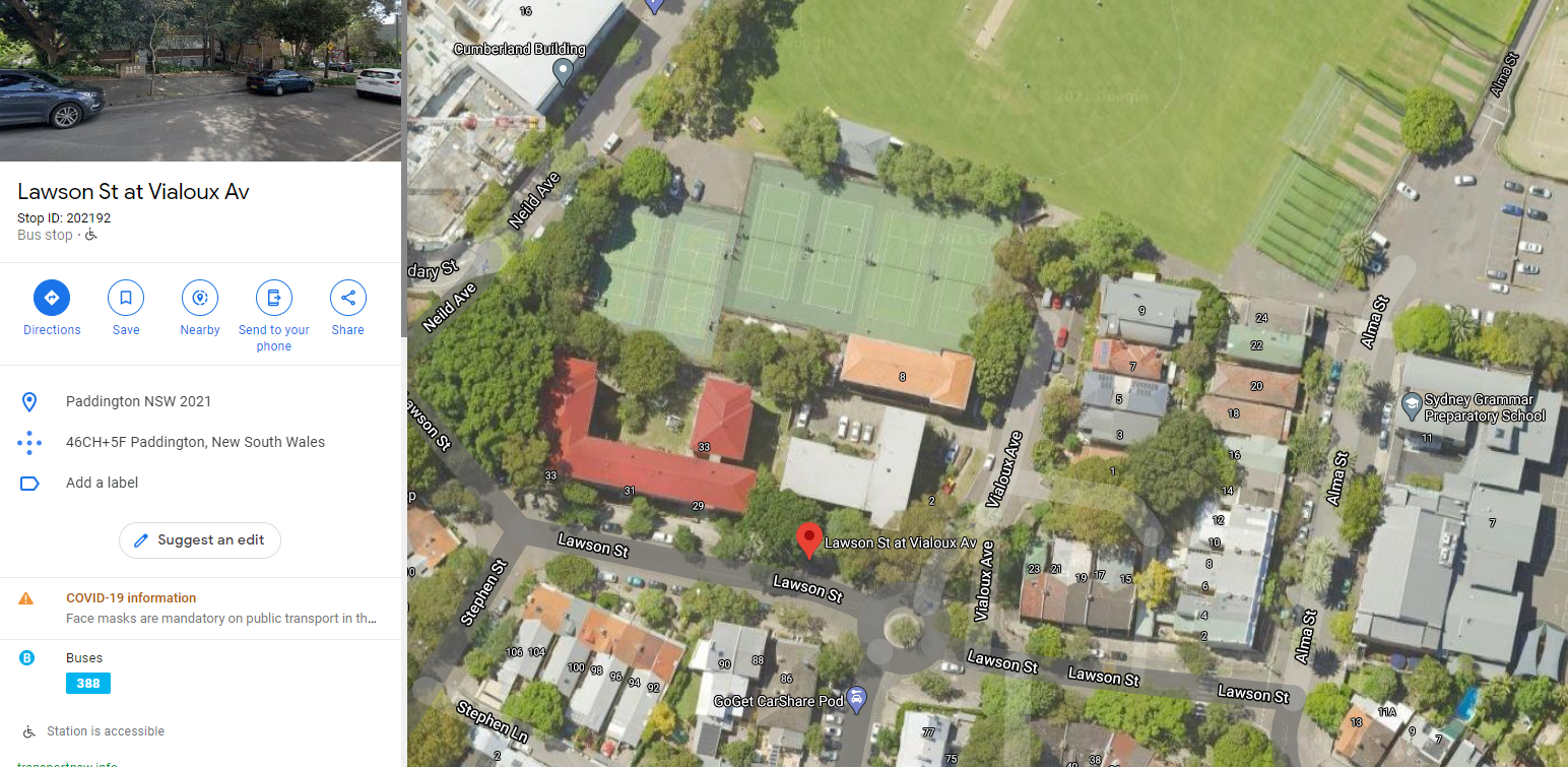
The 388 runs from Lawson Street in Paddington to Bondi Junction. It is basically an annexed version of the more well known 389. Only a single stop (on Lawson St) isn’t also served by the 389.
The weird thing about it? It only runs once. A day. In one direction.
The entirety of the 388 timetable. Yep, that’s the whole thing.
I literally stumbled across the Lawson Street bus stop a couple of years ago and its existence struck me as so weird I reached out to TfNSW to find out why. The reply was a generic ‘operational reasons’ type response, which also hinted at the possibility of extending the service. This hasn’t happened and I must say I’d forgotten about it until last week, when I was surprised to find the 388 is still running!
Why, Oh Why?
The short answer is, I don’t know. My brief exchange with TfNSW didn’t clear it up so I can only speculate. I guess the starting point is to consider what’s near Lawson St and Vialoux Ave, the only stop that really benefits from the existence of the 388. Well, a bunch of things. Mainly Grammar prep school, White City tennis courts, Weigall Oval and a mixture of medium density public and private housing. I suppose the bus could meet the very specific needs of the users of one of these places. What those might be, I have no idea.
This helpful birds eye view of the are surrounding the bus stop at Lawson Street near Vialoux Ave looks great, but doesn’t explain the existence of the 388.
The bus stop in question is within a 500m of walk of both the 389 and New South Head road buses, so it’s not really wanting for access. I’d say it was a weird shopping service to get some belligerent resident to Bondi Junction, but there’s no return bus so that seems unlikely.
My guess would be it came about from some sort of scheduling anomaly, but beyond that, I couldn’t say.
Mapping the 388
Now all that is strange, but not beyond the pale for a transport agency that runs plenty of legacy low frequency routes. What’s stranger still about the 388 is that it’s actually part of a different bus region from the 389 it almost exactly replicates. This basically means that a different organisation operates the 388 from the 389.
The 389 is part of Region 6, Inner West and South operated by Transit Systems, while the 388 is part of Region 9, the Eastern suburbs, operated by State Transit. From a customer standpoint this doesn’t mean much, except for one thing: the 2 routes appear on completely different network maps.
This is exactly the kind of absolute chaos the current wave of network redesigns should be addressing. I spoke about the December 2020 changes to the Northern Beaches region earlier this month and plan on having a deeper look at some of the decisions made in the North West region January 2021 redesign in the near future. Hopefully, a rethink of the Eastern suburbs (and shiny new network map) isn’t too far down the track!
If you’ve ridden, driven or have any additional information about the 388 please get in touch, I need closure!
Just before Christmas 2020 TfNSW introduced sweeping changes to bus services in the most bus dependent part of Sydney, the Northern Beaches. Rather than just tinkering around the edges, or dropping a new flashy service, these changes are a big step towards building a genuinely useful network.
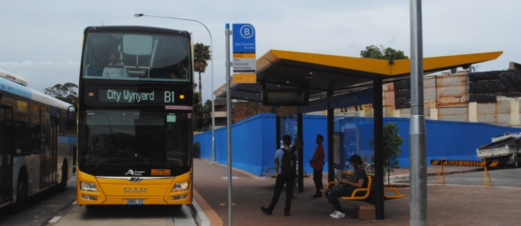
The last big shake up to bus services in the Beaches came with the introduction of the not-quite-BRT B-Line in 2017. The B-Line was a step in the right direction towards best practice bus service design, but pulled up short of being all that it could be. It had great branding, solid bus stops and new vehicles, but lacked anything much in the way of traffic priority. Like the buses it replaced the B-Line spends a lot of time crawling along in traffic.
The B-Line pulls into a bus bay at Spit Junction
Unlike the vast majority of Sydney, the Northern Beaches lack public transport service running on its own right of way. There’s no trains, no metro, no light rail and no t-way. There are a handful of dedicated bus lanes, but mostly only one directional in peak hour and very much placed where there’s room for them, rather than where they are most useful.
Beaches Link and the B-Line
There are plans underway for a brand new, fully grade separated transport corridor to the Northern Beaches, but at this stage it looks like Beaches Link will be for cars and trucks and, if Sydney’s existing motorway network is anything to go by, probably won’t end up being used to any great extent for public transport. From the day this was announced it was clear that a new right of way for public transport into the Northern Beaches was not going to be forthcoming.
And so in 2017, enter: The B-Line. The B-Line was introduced to provide high capacity, high frequency, limited stops service between the CBD and key hubs along the Beaches. A classic bus we choose to catch. It included new park and ride car parks, bike parking, decent bus stop infrastructure and some minor road redesign. In peak hour, much of the B-Line route runs in transit lanes (AKA HOV lanes) or bus lanes, at least in the peak direction. Out of peak most of the route is in general mixed traffic. These arrangements chop and change constantly as the bus makes its way between Mona Vale and Wynyard.
The Beaches Pre B-Line
By the 2010s Sydney was crisscrossed by an absolute mess of a bus network that had evolved erratically in the 60 odd years since the collapse of the tram network it replaced. It was confusing, difficult to navigate and lacked any underlying logic or coherence.
A 2013 plan produced by the State Government optimistically called ‘Sydney’s Bus Future’ outlined a pathway out of that mess and the B-Line was the first real indication that this plan, unlike most of Sydney’s other transport blueprints, might amount to something. Alas, 4 years on and we are still only up to B1 of 13.
Nowhere was this mess more apparent than the Northern Beaches. The area had grown up and out since the bones of the bus network had been laid years earlier. Outdated ideas about CBD-centric workplaces meant that almost all buses went to Wynyard, never mind the burgeoning business parks and retail centres in and around the area. Out of peak public transport was lacklustre and almost everyone who could (unless they were Wynyard bound) chose to drive. This furthered the perception that the Northern Beaches was, errr, not a place that those living elsewhere could easily visit.
An Underwhelming Success
For the first time, the B-Line provided a clear, legible, frequent and fast-ish bus service to the Northern Beaches. Infact the B-Line was so successful at altering the perception of the Beaches as inaccessible, that the State Government’s plan to extend the B-Line to Newport shortly after it opened was quashed by the NRA (Newport Residents Association) citing concerns that a B-Line stop “threatens to increase traffic congestion, threatens our local and beach parking, threatens our trees and threatens our village life”. Must be quite a powerful bus route to achieve all that.
Andrew Constance tells us that in its first year the B-Line carried more passengers than the population of greater Sydney. This fact is definitely cute, but quite meaningless, since I suspect the services it replaced achieved the same feat. And so, without deep diving into data that is probably not readily publicly accessible anyway, it’s difficult to quantitatively say how the B-Line has changed public transport on the beaches. Qualitatively, I can say that the difference is huge. As an occasional visitor it is now simple to understand how to get to any point on the Beaches, at least as far as Mona Vale. Never again will I have to beg the driver of an L90 to let me off at Spit Junction, lost somewhere in the miasma of different express bus stopping patterns.
What the B-Line definitely didn’t do, however, was provide a transport service separate from the woes of the Beaches over capacity road network. What it also didn’t do particularly well was reduce the complexity of the local bus network in the area. When implemented, the B-Line was basically just superimposed over the existing network. A few routes were removed, but it felt like TfNSW were hedging their bets on the success of the program. The network was still designed to give commuters from far flung suburbs a peak hour one seat ride to Wynyard (or occasionally Manly Wharf or North Sydney) and provide a more basic coverage service throughout the rest of the day.
It was hoped (by me), at the time, that the high frequency, high capacity B-Line would function more like a rail service, supplemented by frequent local bus routes connecting to B-Line stops and other local destinations.
Into 2021
3 years later and it seems like those changes are finally being made now. Whether this is because the obvious success of the B-Line has increased the appetite for more radical (and potentially alienating) change, because Covid has shown us that bold policy change can and should occur once in awhile or because it was always the plan but a slowly, slowly approach was considered necessary to avoid revolt.
I suspect it’s a combination of all 3, but regardless, it’s a win for everyone on the Beaches, whether they use public transport or not.
The 199 from Manly to Palm Beach and the 144 from Manly to Chatswood (with that tedious deviation to Royal North Shore removed) are now high frequency services with a 10 minute service all day, 7 days. The 160x, previously the peak hour only L60/E60) has been injected with steroids and is now a high frequency, limited stops service between Dee Why and Chatswood, no longer extending to Mona Vale (change for the B-Line).
Alas, it’s not quite the B2 that residents of the area and anyone interested in good transport planning had been hoping for, but it’s a huge step up for accessibility. Key beneficiaries will be those wanting easy beach access from the North Shore, anyone trying to get by public transport to the new hospital at French’s Forest, and Beaches residents commuting to the Lower North Shore and Macquarie Park area.
Now they just need to paint the buses yellow, give the stops useful names (I’m thinking rename the very catchy ‘Frenchs Forest Rd near Bantry Bay Rd’ to the more helpful ‘Northern Beaches Hospital’), build a few shiny new bus stops with next service screens, throw in a bus lane along Babbage/Warringah/Frenchs Forest Road and viola, the B2. Maybe in another couple of years…
Untangling the Mess
The most remarkable thing about the incremental changes that have been made to the Northern Beaches bus network since 2017 has been the way an outdated and inefficient mess has slowly morphed into a system that actually makes use of best practice network planning strategy.
Take a look at a section of the pre-B-Line network map around the Spit Bridge.
It’s a cacophony of colour and endlessly complex route intermingling. I’m actually kind of impressed that so much information could be synthesised onto a map like this. Of course, unless bus maps are your fetish *ahem*, it’s probably totally unusable to you.
Now compare to that same section, now.
Okay, it’s still a lot, and there’s room for improvement. But after a few seconds, your eyes start to focus in on key information. You think, ‘maybe I can actually use this map to help me get somewhere!’
Two main things have changed.
1. Map legibility.
Colours and line thicknesses have been chosen to reflect the information that is useful to a prospective passenger. Thick Yellow Line = B-Line. Thick dark blue = high frequency. Thin blue = all day local service. Dashed pink = Peak only. Dotted pink = infrequent. ‘X’ designation = express service. Suddenly a casual user can immediately synthesise which routes might be useful for their trip.
2. Route legibility.
Pre B-Line world just had way too many different bus routes. It was a soup that made it extremely difficult to trip plan and almost impossible to find a bus (and get in the right queue) at Wynyard or to flag the right bus anywhere along Military Road. No amount of beautiful map design can make up for the fact that there were just too many bus routes. Pre B-Line there were 45 different bus routes crossing the Spit Bridge. By looking at the map I cannot tell how many of these are peak only or how often they might run. With a quick glance at the Dec 2020 network map I can see that there are now only 14 bus routes that cross the Spit Bridge and that only 4 of them run outside of peak hour. Further, I can see that the B-Line only stops at Neutral Bay Junction and Spit Junction and that the 100 and 144 are all stops frequent services. Amazing!
Incremental Improvements
The importance of change like this should not be understated. Politicians and the public love to obsess over huge shiny glamour projects, but well funded and executed network redesigns can make just as big a change to the wellbeing and productivity of residents.
Thankfully, the Northern Beaches are largely distracted at the moment. With most network restructures like this it’s those that lose out that speak with the loudest voice. Expect complaints from the parts of the Northern Beaches that have lost their twice daily express service to Wynyard, even if they now have an all day service that connects to the high frequency B-Line.
There is, of course, still room for improvement with the network, and thus also the map. The amount of clutter the 229 adds to the map, for a service that runs 5 times a day is frustrating, but leaving this in feels typical of an agency looking to make steady, incremental change. Most routes of this nature have been purged, consolidated into more frequent routes or replaced with on-demand service.
Mosman is still home to far too many low frequency niche bus routes, although these have been reduced slightly since the B-Line. I can’t help but wonder if the door to door one seat ride mentality lingers on in one of Sydney’s most prestigious neighbourhoods, despite being all but dead everywhere else. You could axe the 228, 229, 230, 238 and 246 entirely and not leave anyone stranded without a frequent reliable service a short walk away. In other parts of Sydney a transport agency wouldn’t even consider running so many buses in streets so near to one another. Perhaps a more optimistic reading of these oversights might be that Mosman’s time is soon to come, and those bus routes’ days are numbered.
Orange City Council has announced a new precinct plan for the development of a small area immediately East of the CBD. A series of unrelated events (the relocation of a state government department, the demise of Holden and a planned upsizing of a different car yard) have meant that a roughly contiguous 4.5 hectare area at the doorstep of the CBD is more or less ready to be repurposed.
I haven’t noticed this plan really grabbing any attention locally, but it is actually pretty groundbreaking for the town. A mixed use “precinct” with townhouses, small apartment blocks with ground floor retail and a focus on walkability is par for the course in Sydney, but it doesn’t resemble anything currently in existence in Orange. Or, for that matter, the nearest comparable towns of Bathurst and Dubbo. In the Central West of NSW ‘high density’ is a row of 5 villas on a quarter acre block and new commercial developments tend to take on the US strip mall aesthetic, with plenty of parking out front. Hell, this plan even reduces residential parking minimums to “encourage the use of other modes of transport”. In a town with one registered motor vehicle for every 1.3 people, yes that’s more vehicles than licenced drivers, this is positively radical.
What’s most remarkable about this plan is that it isn’t just a cookie cutter Sydney style mixed use development with as many apartments as possible shoehorned onto a site. There seems to be a genuine desire to integrate the development into the surrounding neighbourhood and improve pedestrian links through the area. The 450m site frontage along the Bathurst Road currently has just 3 pedestrian crossings and is a right pain to cross in peak hour. The precinct plan places an additional 4 pedestrian crossings, giving an average of one every 65 metres, which goes a long way to improving the porousness of the street network in the area. For comparison, to the immediate East of the site, at present there’s a 500 metre gap between safe crossing points. Good pedestrian accessibility in the area clearly hasn’t been a priority until now.
The area under consideration in the Eastside Precinct Plan. Existing pedestrian crossings marked in red and proposed additional new crossings in purple. Source: SIXMaps
Whether or not the plan comes to fruition as envisaged by Council is anyone’s guess, but a large portion of the site is currently sitting vacant, so there’s no doubt a few landowners licking their lips in anticipation.
The Orange property market has been going gangbusters all year, with rental vacancies below 1% and prices moving steadily up. In that climate, you could put any housing stock on the market and rest assured it’ll move quickly. Anecdotally though, it does seem like there’s demand for this type of housing and lifestyle in Orange. The town centre could be described as bustling and pretty much everything the town has to offer can be found within a short walk of the centre. Orange is the sort of town you could easily live in without a car, as long as you didn’t have any desire to ever leave the town. But I’ve complained about the poor state of intercity transport in the region before.
With the growth of the Cadia gold mine, an increasing state government presence, a moderate climate and a booming tourism industry, the town is well positioned to attract the sort of people to which a relatively car free lifestyle might appeal, i.e me. In fact, if the Orange City Council website is anything to go by, these ‘jazz class types’ are exactly who should be moving out West.
A family home that has enough opportunity to expand, schools around the corner, and a five minute drive between jazz class, the supermarket and salsa lessons. A commute to work that means you can sit in a local cafe and have a fresh, locally roasted coffee before you arrive at work – no rushing from platform to street, just easy, stress free living.
I have no idea why houses in Orange might have more opportunity to expand than houses anywhere else, but apparently it’s enough of a point of difference to be the first thing that comes to mind.
It’s worth noting that a precinct plan is really just indicative of the sort of development Council would like to attract to the site. The current owners and prospective developers, as well as the inevitable NIMBYs worried about the changing character of their neighbourhood (I mean who does want their area rebranded as a masterplan ‘precinct’?) , will no doubt have something to say about whether Council’s dream will become a reality. Nevertheless, it’s exciting to see a plan that has bigger dreams for the City than a quaint 19th century main street ringed by ever sprawling suburbia.
The Orange City Council Eastside Precinct Plan is on public exhibition until the 28th of November.